Biodiversity / Landscape
Three environmental indicators describe the development of the environmental good biodiversity/landscape. These are the share of nature conservation areas of the national territory, the condition of the forest and landscape fragmentation. The data are collected by LIKI and TLS.
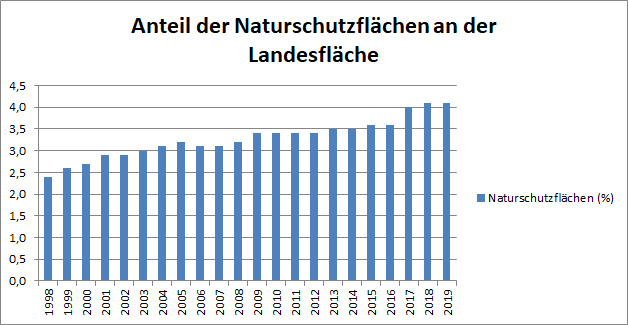
Nature conservation areas
Definition:
This indicator describes the share of nationwide strictly protected areas of nature conservation of the entire land surface in per cent. Nature reserves, national parks and biosphere reserves are included. In order to sustainably safeguard biological diversity, sufficiently large areas are required on which nature can develop without the burden of human intervention. The designation of protected areas is, therefore, one of the most important instruments of nature conservation.
Condition of the environment and development:
The share of nature conservation areas in the total area of the state shows a steady upward trend with smaller interim lows. It can be assumed that positive development will continue.
Chart and table:
| Jahr | Nature conservation areas (%) |
|---|---|
| 1998 | 2,4 |
| 1999 | 2,6 |
| 2000 | 2,7 |
| 2001 | 2,9 |
| 2002 | 2,9 |
| 2003 | 3,0 |
| 2004 | 3,1 |
| 2005 | 3,2 |
| 2006 | 3,1 |
| 2007 | 3,1 |
| 2008 | 3,2 |
| 2009 | 3,4 |
| 2010 | 3,4 |
| 2011 | 3,4 |
| 2012 | 3,4 |
| 2013 | 3,5 |
| 2014 | 3,5 |
| 2015 | 3,6 |
| 2016 | 3,6 |
| 2017 | 4,0 |
| 2018 | 4,1 |
Source: Länderinitiative Kernindikatoren, B3 - Nature conservation areas: Table Share of strictly protected nature conservation areas of the national territory
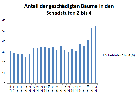
Condition of the forest
Definition:
The forest condition indicator shows the percentage of damaged forest area. The following classification applies: degree of forest damage 0 = without damage characteristics, 1 = slightly damaged, 2 = moderately damaged, 3 = severely damaged, 4 = dead.
Condition of the environment and development:
With the reduction of air pollutants, the percentage of considerably damaged trees had also been significantly reduced by 2002. However, climate change and the resulting extreme weather conditions (e.g. record summer 2003 with extremely dry and warm weather) are increasingly exerting additional stress on forests. A clear trend is not apparent for the time being.
Chart and table:
| Jahr | Degree of damage 2 (%) | Degree of damage 3 (%) | Degree of damage 4 (%) | Degrees of damage 2 to 4 (%) |
|---|---|---|---|---|
| 1998 | 29 | 2 | 0 | 31 |
| 1999 | 28 | 1 | 0 | 29 |
| 2000 | 27 | 1 | 0 | 28 |
| 2001 | 26 | 2 | 0 | 28 |
| 2002 | 24 | 1 | 0 | 25 |
| 2003 | 26 | 2 | 0 | 28 |
| 2004 | 33 | 1 | 0 | 34 |
| 2005 | 32 | 2 | 0 | 34 |
| 2006 | 33 | 2 | 0 | 35 |
| 2007 | 33 | 2 | 0 | 35 |
| 2008 | 33 | 1 | 0 | 34 |
| 2009 | 34 | 1 | 0 | 35 |
| 2010 | 31 | 1 | 0 | 32 |
| 2011 | 35 | 1 | 0 | 36 |
| 2012 | 31 | 1 | 0 | 32 |
| 2013 | 29 | 1 | 0 | 30 |
| 2014 | 32 | 1 | 0 | 33 |
| 2015 | 30 | 1 | 0 | 31 |
| 2016 | 36 | 1 | 0 | 37 |
| 2017 | 35 | 1 | 0 | 36 |
| 2018 | 38 | 3 | 0 | 41 |
| 2019 | 46 | 6 | 1 | 53 |
SOurce: Thuringian State Office for Statistics: Air pollution: Table: Damaged forest areas by degree of damage in Thuringia; Forest Condition Report 2019: Table 3 Forest condition by tree species
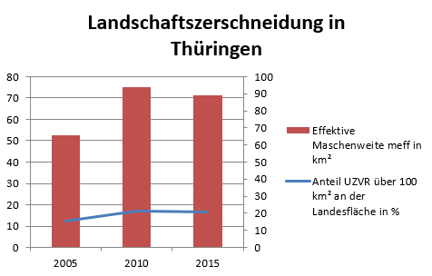
Fragmentation of landscape
Definition:
The indicator measures the extent to which the landscape is fragmented by technical elements that cause disturbance to wildlife, experiencing nature and recreation suitability. As technical elements dissecting the landscape all roads with a traffic volume of 1000 motor vehicles / 24 h (federal motorway, federal and state roads, district roads, as far as count data are available), double-track railway lines and single-track electrified (not closed down), localities, airports and canals with the status of a federal waterway of category IV or higher are considered. A distinction is made here between two key figures; on the one hand, the percentage of undissected low-traffic areas over 100 km² of the surface area and, on the other hand, the average degree of land dissection, expressed by the effective mesh size in km². The effective mesh width (or mesh size) meff is proportional to the probability that two arbitrarily selected points lying in an area are still together in the same area after the dissection of the area. The effective mesh size is specified as area size in km². The more settlements and roads are located in a certain area, the lower the probability of non-dissection, and the more the effective mesh size decreases.
Meaning:
In terms of sustainable development, the largest possible unfragmented spaces and a low degree of dissection are essential.
The designation of new construction areas for commercial and residential use, the construction and expansion of roads and other infrastructure as well as the steadily growing traffic lead to the loss, reduction in size and increasing fragmentation of habitats. The system and operation-related effects of infrastructure increasingly contribute to the endangerment of animal species and their habitats. Large, undissected habitats are vital for animal species that require a lot of space and have a large radius of action. In particular, large mammals with a high space demand can only move around the landscape to a limited extent, i.e. without crossing the road network. The mortality of these species on roads with high occupancy increases considerably unless a crossing of the road network is not completely prevented. The possibility of animals of the same species meeting is an essential condition for gene exchange and population survival. It is also important for people's experience of nature and the quality of recreation to preserve spaces that are largely undissected and not noisy. Spaces with little urban sprawl, fragmentation and noise represent a finite resource and can only be restored, if at all, at great expense.
A low degree of landscape fragmentation and large undissected areas are therefore essential touchstones for sustainable development.
Chart and table:
| year | Share of undissected low-traffic areas above 100 km² of surface area in % | Effektive mesh size meff in km² |
|---|---|---|
| 2005 | 15,63 | 52,73 |
| 2010 | 21,48 | 75,10 |
| 2015 | 20,86 | 71,31 |
Source: Länderinititiative Kernindikatoren, B1 - Landscape fragmentation: tables Percentage of undissected low-traffic areas over 100 km2 of the national territory in [%] and effective mesh size meff in [km²]